Pages
86
It was the intention of the Coast Guard to make the most possible use of RADAR and other electronic devices in order to increase the efficiency of its public services, One shore base installation was established and two installations were tentatively scheduled to be used as an experimental setup to determine whether necessary coverage could be provided for air sea rescue operation. No program other than experimental had been devised for furnishing coverage for the protection of small craft along the coast and in the harbors.
The District Coast Guard Officer of each District was directed to investigate the possible applications of shore based RADAR to the particular problems of his District. Consideration was given to the need of air sea rescue to provide warning of potential or real distress, to determine the assistance to possible control of shipping in and around harbors and the use of RADAR as a supplementary aid for coastal lookout as well as in checking the positions of navigational or any other applications which would increase the efficiency of Coast Guard functions. Results of these investigations by the District Coast Guard Officers were submitted to Headquarters in order that no phase of RADAR application was overlooked in overall study.
The end of the war found the District not only operating 14 RACON Stations, but a new electronic aid, LORAN, with stations at Cape Blanco, Oregon, Point Grenville, Washington and Spring Island in Vancouver, B.C. A Monitor Station for LORAN had been set up at Yaquina Head, Oregon. Installation and supervision of LORAN was controlled entirely by Headquarters. However, on survey trips to determine sites for the various stations, representative of the District Coast Guard Officer, 13th Naval District, had been present. The original installations at the aforementioned stations were temporary, in that they were mobile units, contracts having been let to private industry for the construction of permanent stations. The aids to Navigation Office distributed 1500 temporary LORAN navigation charts covering the coast from Cape Blanco to Spring Island to Army, Navy and Canadian Air Stations, as well as innumerable warships. These two stations were the "Slaves" with the "Master Station" located at Point Grenville, Washington. Headquarters Detachment "G", which was in supervision of the District LORAN Units, operated with headquarters at Newport, Oregon. All stations operated on a 2H4 rate. Favorable reports were received from mariners who had picked up the pulse from the mobile units at great distances at sea.
87
Indirectly, the Aids to Navigation Section figured in installation of the LORAN on Spring Island off the coast of British Vancouver. Equipment to be moved to the Island from Seattle included trucks, jeeps, weapon carriers, Quonset Huts, materials and equipment for clearing land as well as supplies for 34 men to be stationed there during temporary service. The only ship available in the District for the transporting of these supplies and men, was the tender BASSWOOD. The BASSWOOD made several voyages to transfer equipment until the tender was assigned to the South Pacific, (see tenders), and an Army Freight Ship was sent as relief. The completion of Spring Island as a LORAN Station added another link in the LORAN system covering the West Coast from Mexico through Alaska.
In addition to its previous peace time function, the Aids to Navigation Section, had expanded to include in its duties the 14 RACON Stations maintenance and operation as well as three LORAN Stations together with their monitor Station. The assistance rendered by LORAN, for distances at sea to 1400 miles, was a far cry from the guiding light of the early LIGHTSHIP NO. 50 whose oil lantern set out a gleam a scant 10 miles. And, in addition, not only the sea but the air became safe as LORAN Helped pilots fix their positions with pin-point accuracy. The Coast Guard had made the air, as well as the Sea, safer for navigation.
88
LOCAL NOTICE TO MARINERS
A special function of the Lighthouse Service had long been the issuance of daily notices to local mariners concerning current data of District waters. After the consolidation, the Notice to Mariners continued to be published over the signature of the Commander, Seattle District and later, the District Coast Guard Officer.
Information for the notices was received from Coast Guard, Navy, Army Engineers, Merchant vessels, Canadia authorities or any unit or individual finding a discrepancy in any navigational aid or menaces to safe navigation. Misplaced buoys or extinguished lights, defective signals in sound or light, derelicts, logs, debris of any sort which constituted a menace, soundings of newly dredged areas, new regulations and limitations of restricted areas were the bulk of information published.
The Notices were numbered consecutively, number one being issued at the beginning of each clendar year. In 1944, there were 183 more notices published than in 1934, the increase being due to the war restrictions, floating rafts, unexploded depth charges and the submarines menace. Notices were not published on Sunday nor on days when no changes in aids had occurred. This data was broadcast, during the war, over local commercial radio stations during a sponsored program for the Coast Guard. This program was discontinued at the close of hostilities. 1850 copies were distributed daily to a mailing list of 550 units or individuals in 1945. In 1939, 91 addresses received the Notice. This tremendous growth was due to the heavy war traffic of merchant and naval vessels.
Mariners depend whole heartedly upon these Notices as guides for safe navigation. Evidence of this has been shown in the alacrity with which operators notify the Aids to Navigation Section of discrepancies in aids or menaces which they sighted during their activities.
89
CARD FILE SYSTEM
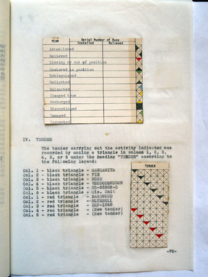
A card record system was developed in the Aids to Navigation Section for each buoy in the District, arranged geographically in a visual card file with visual color signals indicating the general progress in buoy relief work and other pertinent information. On the face of the card was typed the name and the Light List number or page number of the buoy. The various activities or conditions were noted on the card according to the following outline as indicated on the attached key:
I. YEAR
The current year was typed below the heading "YEAR". Only one line was required for the year unless one or more of the following conditions existed: a. More than one buoy installed in one year. b. More than four sections in one year. c. Extinguished and off-station same month. d. Relieved, relocated, changed type of damage same month.
II. SERIAL NUMBER OF BUOY Under this heading the serial numbers of the buoys were typed whether installed or relieved.
III. MONTH Each line in this section was divided into 21 squares, one for each month of they year. Each square was divided into 4 triangles. By placing different colored triangles in the various positions, the section taken was indicated according to the following legend:
-69-
90
Year Installed Relieved
Established Relieved Missing or out of position Restored to position Extinguished Relighted Relocated Changed type Recharged Discontinued Damaged Inspected
IV. TENDER
The tender carrying out the activity indicated was recorded by making a triangle in column 1, 2 ,3 4, 5, or 6 under the heading 'TENDER" according to the following legend:
Col. 1 black triangle -MANZANITA Col. 2 black triangle- FIR Col. 3 black triangle-ROSE Col. 4 black triangle-[REODODENDRON?] Col. 5 black triangle-[OG-65302-D?] Col. 6 black triangle-Mis. Unit Col. 1 red triangle -Basswood Col. 2 red triangle-Bluebell Col. 3 red triangle-BSP-1048 Col. 4 red triangle- (New tender) Col. 5 red triangle-(New tender)
Chart to right of IV. Tender