Pages That Mention Yaquina Point
1884 Not CF but YH Vol. 610
4
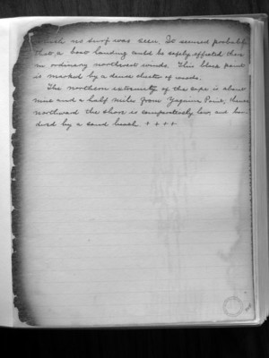
which no surf was seen. It seemed probable that a boat landing could be safely effected there in ordinary northwest winds. This black point is marked by a dense cluster of woods.
The northern extremity of the cape is about nine and a half miles from Yaquina Point; thus??? northward the shore is comparatively low, and bordered by a sand beach. ++++
Box 45 CF missing boxes of lens glass and skylights 1873
3
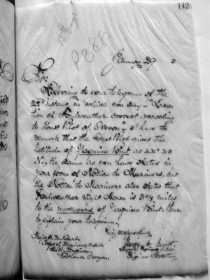
January 29 (187)3
Sir: Referring to your telegram of the 22 instant, in which you say- "Location of Foulweather correct according to Coast Pilot of Oregon"- I have to remark that the Coast Pilot gives the latitude of Yaquina Point as 44° 40 N., the same as you have stated in your form of Notice to Mariners, but the Notice to Mariners also states that Foulweather Light House is 3 3/8 miles to the northward of Yaquina Point. Please to explain your telegram.
Very respectfully, George H. Elliot Major of Engineers, U.S.A. Engineer Secretary
Major H. M. Robert. Corps of Engineers, U.S.A. L. H. Engineer. Portland, Oregon.
p-2 Notice To Mariners
2
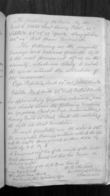
The position of the tower, by the United States Coast Survey Pilot, is: Latitude 44 degrees 36 minutes 35 seconds north, Longitude 124 degrees 04 minutes west from Greenwich.
The following are the magnetic bearings and distances from the light to the most prominent objects in the vicinity, which are likely to catch the eyes or attract the attention of the mariner:
Cape Perpetua, South 20 degrees east, distant 26 miles. Celilike Head, South 17 1/2 degrees east, distant 8 miles.
In approaching Yaquina entrance, mariners should observe the following directions, viz: Yaquina Point (or Cape Foulweather) bearing north 34 degrees west, limits the visibility of the light in that direction.
The angle of visibility over the water is 238 degrees. The magnetic bearings, within which the light will be visible from a vessel, are from N.N.W. by southerly to S. by E.
A dangerous reef lies off the mouth of the harbor. Vessels passing should not have less than 12 fathoms water.
By order of the Light-House Board:
Treasury Department Office Light House Board Washington, D.C. September 1871
W.B. Shubrick, Rear Admiral, U.S. Navy Chairman
1870-73 Lighthouse Board Annual Reports
40
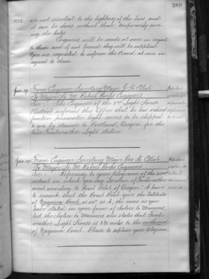
1873 are not essential to the lighting of the lens and it can be done without them, temporarily covering the holes. Enquiries will be made at once in regard to them, and if not found they will be supplied. You are requested to inform the board at once in regard to them.
Jan. 29 From Engineer Secretary Major G.H. Elliot To Major H.M. Robert Corps Engineers Sir: The Engineer of the 3rd Light-House District informs this Office that he has ordered fourteen prismatic light-covers to be shipped to you by steamer to Portland, Oregon for the Cape Foulweather Light Station.
Jan. 29 From Engineer Secretary Major Geo. H. Elliot To Major H.M. Robert Corps Engineers Sir: Referring to your telegrams of the 22nd instant in which you say "Location of Foulweather correct according to Coast Pilot of Oregon" I have to remark that the Coast Pilot gives the latitude of Yaquina Points 44 40N., the same as you have stated in your form of Notice to Mariners, but the Notice to Mariners also states that Fourweather Light House is 3 3/8 miles to the northward of Yaquina Point. Please to explain your telegram.