Pages That Mention Channel Limiting Group
Coast Guard District narrative histories 1945
9
A monitor station was established at North Head Radio Station which checked the performance of all District Radio Beacons, and outlying stations were notified daily of all failures or defects in the radio beacons' operation. These reports were a District innovation and were not required by Headquarters but were merely another measure adopted by the District Coast Guard Office for increased efficiency in the District system. In March, 1944, Radio Station Meadowdale was ??? as a Monitoring Station for radio beacons, as the activities at that station had been considerably reduced. Although Headquarters' instructions ordered that each radio beacon in the United States be monitored at least once every four hours, it became possible in the 13th Naval District, to monitor each radio beacon every hour after the new monitor station had been added.
AIDS TO NAVIGATION IN UPPER COLUMBIA RIVER
In 1932 navigation in the Upper Columbia was revived for the transportation of wheat, but the servies between the Upper and Lower Ports was intermittent. This renewal of navigation was more or less on a trial basis to determine if sufficient commerce could be developed to support water carrier operation. Sufficient traffic was realized and, after the construction of the Bonneville Dam which was completed in 1938, river traffic expanded into the movement of great steel barges designed to carry liquid petroleum in the hull and package or bulk cargo on deck. With this increased traffic from Astoria, Oregon, beyond The Dalles, Oregon, the necessity of navigational aids to insure the mariner's safety became most apparent. As a result, the Aids to Navigation Section centered the majority of its activities in the promotion of safe navigation along the river. Here was the proving grounds for experimental light structures and buoys to determine those most suitable for the area. Due to the rapid current, range marking channels had to be so perfected as to enable the mariners to ascertain their course in a matter of seconds.
It was also necessary to experiment with range markings, and in this connection the Nautical Scientist in the Aide to Navigation Section, 13th Naval District, invented and constructed a system of laterally restricted range markings. This newly devised "Channel Limiting Group" was necessary because of the impossible terrain which made the establishment of the conventional markings impracticable if not impossible. With Headquarters' approval an experimental range was established on the Columbia River near Arlington, Oregon, which proved to be successful. Other experiments were concerned principally with surface riding buoys and fast water buoys.
-26-
46
actuality except for the initial voyage of such a vessel to The Dalles, Oregon, in 1939 to prove the channel was large enough for traffic of this type. A conference with marine interests was held in 1943 and a program for proposed aids between Vancouver, Washington and Bonneville was drawn up. The necessity for additional aids was intensified by the continual requests from government agencies to increase the total tonnage on the Columbia River because, due to the manpower shortage, inexperienced men were operating vessels over these treacherous waters and also because almost all railroad tank cars had been taken out of the area due to the war emergency. This placed an exceedingly large burden on the water carriers to transport the required petroleum products for the Army and Navy Air Forces on the Columbia River. The area was marked, at that time, by 6 ranges, 26 lights and 2 beacons.
The new program presented to Headquarters in 1945 requested that 51 structures be electrified and that duplex lanterns be replaced by single General Railway signal, Type "SA" lanterns in order to simplify and standardize equipment. This proposed project was approved by Headquarters and work began instantly. The contour of the shore in this area, near Multnomah Falls, created precipitous cliffs rising almost from the water's edge which prevented the use of the customary range, and, consequently, it was proposed to install experimental channel limiting group lights which had been temporarily established at Arlington beyond The Dalles, Oregon. (See Arlington Channel Limiting Group Lights under "Experimental Range Markings".) Headquarters disapproved the use of the new ranges and as a result, the area was left inadequately marked as the conventional two board ranges could not be established on the sheer banks. (A great number of the rear lights of conventional ranges installed above Celilo were fixed instead of flashing. When the lights were first installed, both front and rear lights were flashing. As this section of the river was very dangerous due to the rocks and whirlpools and side currents, the operators of the boats had very little time for observation of ranges which were astern when going up the rapids as the current and the whirlpools were continually changing the boat's course. If the light was at an eclipsed state when the operator looked back at the range, he was unable to determine whether or not he was on the course as very little time could be spent looking for the range.)
-27-
50
the daymark to prevent their whole surface from being filmed with sand and dust. The Scotchlite was installed in other District Areas, mainly Coos Bay, with hearty approval of the mariners in the Bay.
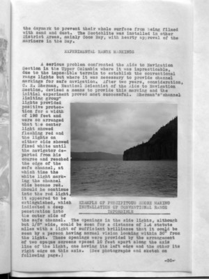
A serious problem confronted the Aids to Navigation Section in the Upper Columbia where it was impracticable, due to the impossible terrain to establish the conventional range lights but where it was necessary to provide channel markings for safe navigation. After two years, consideration, C. E. Sherman, Nautical Scientist of the Aids to Navigation Section, devised a means to provide this marking and the initial experiment proved most successful. Sherman's "channel limiting group" lights provided positive protection for a width of 198 feet and were so arranged that the center light showed flashing red and the lights on either side showed fixed white until the navigator departed from his course and reached the edge of the safe channel, at which time the white light marking the channel side became red. Should he continue into the red light, it appeared to be extinguished, which indicated a deep penetration into the outer side of the safe channel. The openings in the side lights, although but 1/8" wide, could be seen for a distance of 1.4 statute miles with a light of sufficient brilliance that it could be seen by a person having normal vision looking within 30° from the light. These openings were provided by the arrangement of two opaque screens spaced 10 feet apart along the axis line of the light, one having its left edge and the other its right edge on this axis. (See photographs and sketch on following page.)
(image) EXAMPLE OF PRECIPITOUS SHORE MAKING INSTALLATION OF CONVENTIONAL RANGE IMPOSSIBLE
-30-
53
Tests of the channel limiting group equipment were observed by the District Engineering and Marine Inspection Officers and it was their recommendation that it was worthwhile to establish and to put into use such an experimental range on the Columbia River. This was done at Arlington, Oregon, with Headquarters' approval, in the Spring of 1945. An investigation of the success of this type of range indicated that the majority of the operators preferred the old type regular center line lighted range of two boards. This preference, in the opinion of the District Coast Guard Office, was made primarily because of the lack of understanding and the use of the limiting channel range and, consequently, detailed printed instructions were issued to all operators in the Celilo-Pasco District where the Arlington range was located. As a result, more favorable comments were received in regard to the use of the limiting channel lights, but, notwithstanding, Headquarters would not authorize their establishment on other ranges where the two-board range was impracticable because of the terrain. This policy, which Headquarters adopted, left areas in the Columbia River unsafe for navigation as the lights and markings which could be established there provided only inadequate coverage.
INCREASE OF AIDS AND CHANNEL IMPROVEMENTS
Recommendations for the increase of aids to insure safety of mariners in the Upper Columbia were presented to the District Coast Guard Officer and Headquarters by the Board of Survey. Headquarters felt that complete justification for the project as a whole, as being vital to the war effort, had not been furnished, and requested that a complete list of all shipping interests concerned, the extent of their operations, and a list of all government agencies involved there in the war interest, be furnished. Letters from navigation companies indicating the large burdens placed on water carriers to transport the required petroleum products to Army and Navy installations on the Columbia were forwarded to Headquarters together with freight tonnages and traffic statistics. The proposed improvements were then approved and an appropriation of $50,000 was granted. (June, 1940). Additional appropriations were granted later.
The Snake River, which enters the Columbia just south of Pasco, Washington, was not navigable except during high water from the middle of March to the middle of July. At the time of the survey, the U. S. Army Engineers were contemplating the improvement of the Snake River by providing a
-33-