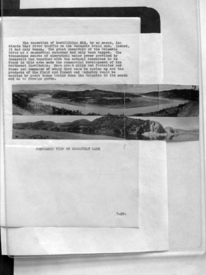
Pages That Mention Roosevelt Lake
Coast Guard District narrative histories 1945
10
(image)
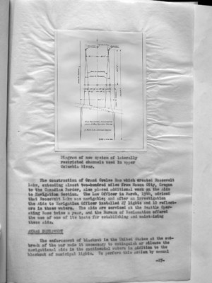
Diagram of new system of laterally restricted channels used in upper Columbia River.
The construction of Grand Coulee Dam which created Roosevelt Lake, extending almost two-hundred miles from Mason City, Oregon to the Canadian Border, also placed additional work on the Aide to Navigation Section. The Law Officer in March, 1944, advised that Roosevelt Lake was navigable; and after an investigation the Aids to Navigation Officer installed 27 lights and 10 reflectors in those waters. The aids are serviced at the Seattle Operating Base twice a year, and the Bureau of Reclamation offered the use of one of its boats for establishing and maintaining these aids.
ANRAC ??? EQUIPMENT
The enforcement of blackout in the United States at the outbreak of the war made it necessary to extinguish or silence the navigational aids in the continental waters in addition to the blackout of municipal lights. To perform this action by manual
-27-
54
channel five feet deep from the mouth of the Snake to Lewiston, Idaho, 139 miles upstream. However, this portion of the river presented additional problems in that the rise in elevation to Lewiston from the mouth was 400 feet and the waters swift and shallow. Army Engineers had surveyed this section in 1934 at a cost of $150,000.00 but by 1940 the survey marks were missing and existing maps of the river were unreliable. Althought railway lines paralleled the Snake River on either side to Lewiston, most of the shipping in the area was done by barge as the freight charges for rail transportation was excessive. In anticipation of the Army's proposed dredging, wheat elevators had been constructed along the banks of the Snake, in spite of the fact that river traffic had been discontinued for some time prior to the Army's proposed project. Improvement of the Snake River was calculated to reduce the price of waterborne gasoline about 1 cent at Lewiston and 3/4 cent at Spokane and to insure navigation at least nine months of the year. On the strength of the Army's proposal, Headquarters allotted $33,000.00 for the establishment of aids along the Snake to Lewiston but this was later diverted to other projects as so little progress was made by the Army in the dredging of the proposed channel by 1945.
Ranges were not established even though there was a minimum of river traffic near Lewiston as the Board felt that the establishment of any aids implied responsibility for the safety of the courses over which soundings and chart data were incompleted. By the end of World War II, river traffic on the Columbia had reached a peak. Day and night, winter and summer, through fog or clear weather, tugs and barges, fishing boats and other commercial marine craft plied the river from Astoria, Oregon to Pasco, Washington. The Upper Columbia had been thoroughly marked with additional aids to insure safe navigation; Army Engineers had dredged channels to promote commerce; and inland navigation companies had increased their tonnage so that by 1945 the Columbia River had taken its place amongst the top ranking commercial waterways of the world. But, at Pasco, extensive river traffic ceased for beyond this point the conditions of the river made through traffic impossible. Although the Columbia reached for hundreds of miles beyond Pasco, Washington, all commerce was localized in small areas along its length.
AIDS IN ROOSEVELT LAKE
The building of the Grand Coulee Dam on the far reaches of the Columbia, to provide water for irrigation and water power for this great Northwest section, brought about additional activities for the Aids to Navigation Section. The building of the dam created a lake which extended almost 200
-34-
55
miles from Mason City to the Canadian border. A question arose as to whether or not Roosevelt Lake constituted part of "the navigable waters of the United States" as interpreted by the laws. In March, 1944, the Law Officer advised that Roosevelt Lake was navigable and, together with the Columbia River which flows into it and gives rise to it, furnished a water way for foreign commerce. With this fact established, it became necessary to establish aids to navigation along the lengths of this lake. At that time, there was very little traffic on Roosevelt Reservoir but it was the opinion of local marine interests that the traffic was bound to increase not only commercially but in pleasure craft following the war. Numerous hazards existed that made travel especially dangers under the conditions as they then existed. In a meeting between the Superintendent of the Coulee Dam and representatives of the District Coast Guard Officer, location were proposed for spar buoys to be anchored in the lake and provide the shortest run from Grand Coulee Dam to Kettle Falls, Washington. These locations were consistent with assumed limitations of 20 feet of water at buoy locations with a maximum reservoir drawdown at elevation 1208 and a minimum distance between the buoys 1/2 mile; the normal elevation of the reservoir when full is 1290. An investigation made by the Aids to Navigation Officer determined that 27 lights and 10 reflectors would suffice to mark the lake. The Bureau of Reclamation was in favor of the establishment of 51 buoys but the District Coast Guard Officer felt that buoys would be impracticable for several reasons. Due to the lowering of the water to different levels which would cause different shoal areas to appear and changes would have to be made in the buoys to keep the channel safely and effectively marked. Furthermore, the mountainous land area which formed the bottom of the lake together with the deep water, rendered use of buoys inadvisable; for in many places the buoys would be moored in over 200 feet of water which would require large buoys and, consequently, the services of a buoy tender. Unlighted buoys were not considered, for, as such, they would be inadequate. For these reasons then the Aids to Navigation Officer determined that the 27 lights and 10 reflectors would be adequate. These lighted aids would consist of a battery box on a concrete foundation with a 200mm lantern with a focal plane of 12 feet. Aids were to display a white light of 90 candlepower, flashing either every 4 seconds, 6 seconds or 10 seconds, and were to be serviced by the Seattle Operating Base twice a year with half of the batter cells being relieved at a time. The Bureau of Reclamation extended the use of one of its boats to be used in establishing these aids and in the servicing of them.
-35-
56
Work in this area was not begun until the later part of the Summer, but the operators, in the early Spring, began to urge that some assistance be given them as the waters were entirely without navigational aids and it was necessary to maintain a regular service including night travel in the transportation of lumber and direct war supplies. Due to the lack of lights, the operators were constantly damaging marine equipment and retarding the flow of this important traffic. Marine Inspectors had established Coast Guard Operating Regulations in this area and operators were finding it almost impossible to comply with these regulations under the circumstances. They pointed out that the installations of equipment such as were direly needed in the Roosevelt Lake were being made in other inland waters where cargo, generally, did not have the high war rating as in their area. They understood that complete coverage of the area could be made. In spite of the urgency of this request, the District Coast Guard Officer did not feel that temporary measures could be taken and, consequently, Roosevelt Dam aids were not established until August, 1945. The War Department issued a permit for a boom to be established below Peach to catch any drift from the Upper Columbia River before it reached the Dam. Brush so caught by the boom was to be dragged ashore and disposed of by burning. The boom was to be installed in two sections, one slightly upstream from the other, but overlapping its length so as to permit boats to pass around the ends of the boom on their way either up or down the river. Headquarters, at the request of the War Department recommended that the District prescribe such lights or signals as were necessary. The District Coast Guard recommended the reflector type lens which required no electric or automatic power for operation.
In December, 1944, a representative of the Aids to Navigation Office surveyed the area of Coeur d' Alene, Idaho, for navigational lights on the lake. As a result, it was determined that lights and reflectors were necessary as there was considerable traffic in lumber and war supplies. Before approval was received from Headquarters for these installations, a second survey was made, approximately six months later, to determine the exact locations. (It had been impossible and impracticable to spot exact locations in the December Survey.) The results of the second investigation were that 9 lights were proposed, subject to Headquarters' approval. Headquarters, however, did not favor the proposed program for aids to navigation in Coeur d' Alene as there did not seem to be sufficient traffic bearing on the war effort and also because the war was drawing to a close. (13 August, 1945). Headquarters indicated that if sufficient evidence was presented for the need for aids in that area at some future date, the program would be given consideration.
-36-
57
The cessation of hostilities did, by no means, indicate that river traffic on the Columbia would end. Indeed, it had only begun. The great reservoir of the Columbia River as a commercial waterway had only been tapped. The tremendous source of electrical water power provided by Roosevelt Dam together with the natural resources to be found in this area made the commercial development of the Northwest inevitable. Here great mills and factories and farms and commerce of every sort were to spring up and the products of the field and forest and industry would be carried by great barge trains down the Columbia to its mouth and on to foreign ports.
(image) PANORAMIC VIEW OF ROOSEVELT LAKE
-37-