Pages That Mention Navy
p-2 Notice To Mariners
2
The position of the tower, by the United States Coast Survey Pilot, is: Latitude 44 degrees 36 minutes 35 seconds north, Longitude 124 degrees 04 minutes west from Greenwich.
The following are the magnetic bearings and distances from the light to the most prominent objects in the vicinity, which are likely to catch the eyes or attract the attention of the mariner:
Cape Perpetua, South 20 degrees east, distant 26 miles. Celilike Head, South 17 1/2 degrees east, distant 8 miles.
In approaching Yaquina entrance, mariners should observe the following directions, viz: Yaquina Point (or Cape Foulweather) bearing north 34 degrees west, limits the visibility of the light in that direction.
The angle of visibility over the water is 238 degrees. The magnetic bearings, within which the light will be visible from a vessel, are from N.N.W. by southerly to S. by E.
A dangerous reef lies off the mouth of the harbor. Vessels passing should not have less than 12 fathoms water.
By order of the Light-House Board:
Treasury Department Office Light House Board Washington, D.C. September 1871
W.B. Shubrick, Rear Admiral, U.S. Navy Chairman
Coast Guard District narrative histories 1945
5
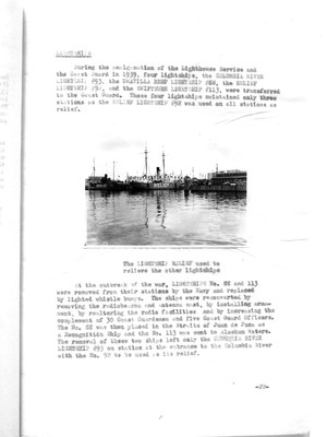
During the amalgamation of the Lighthouse Service and the Coast Guard in 1939, four lightships, the COLUMBIA RIVER LIGHTSHIP 393, the UMATILLA REEF LIGHTSHIP #88, the RELIEF LIGHTSHIP #92, and the SWIFTSURE LIGHTSHIP #113, were transferred to the Coast Guard. These four lightships maintained only three stations as the RELIEF LIGHTSHIP #92 was used on all stations as relief.
(Photo of Relief Lightship displayed with caption below)
The LIGHTSHIP RELIEF used to relieve the other lighthships
At the outbreak of the war, LIGHTSHIPS No. 88 and 113 were removed from their stations by the Navy and replaced by lighted whistle buoys. the ships were reconverted by removing the radiobeacon and antenna mast, by installing armament, by realtering the radio facilities and by increasing the complement of 30 Coast Guardmen and five Coast Guard Officers. The No. 88 was then placed in the Straits of Juan de Fuca as a Recognition Ship and the No. 113 was sent to Alaskan Waters. The removal of these two ships left only the COLUMBIA RIVER LIGHTSHIP #93 on station at the entrance to the Columbia River with the No. 92 to be used as its relief.
-22-
8
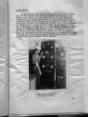
At the time of the consolidation of the Lighthouse Service and the Coast Guard, the Seattle District operated nine land-based radio beacons and four radio beacons on the lightships. Two beacons were under construction at Destruction Island (completed in 1943) and at Willapa Bay (completed in 1941). Two more radio beacons were authorized in 1942, one at Cape Flattery (Tatoosh Island) and one at West Point. In the middle of 1945, the radio beacon at Ediz Hook was established, bringing the total number of District radio beacons to 18. However, at the onset of the war, the Navy removed the lightships from the Umatilla Reef and Swiftsure Bank thus leaving only 16 beacons in operation. Of these 16, one was maintained by the RELIEF LIGHTSHIP and used alternatively on the Columbia River station.
(Photo inserted here)
Radio beacon equipment at Tatoosh Island
-25-
11
labor consumed far too much valuable time, and so it became expedient that there be a swifter method. By 1942, Headquarters developed a radio control system for aids to navigation intended primarily for blacking out unattended lighted aids by means of radio signal. The system was designated by the coined word "RACAN" which was later changed to ANRAC to avoid confusion with RADAR beacons or RACONS.
After a thorough study of the use of ANRAC, the District Coast Guard Officer, 13th Naval District, requested Headquarters' authority to install the equipment with the Cape Disappointment Light Station as the control unit for the radio extinguishing of ten buoys in the lower Columbia River. Because of the delay in the delivery of ANRAC equipment, it was not until March, 1944 that the first two ANRAC equipped buoys were placed on station. All maintenance and repair work for this installation of special buoy equipment was handled at the Tongue Point Repair Base, Tongue Point, Oregon. Later at the request of the Commandant, 13th Naval District, the District Coast Guard Officer requested that ANRAC controlled buoys be placed in the Grays Harbor and Willapa Bay areas. Headquarters authorized these installations, but later experiments with ANRAC did not prove satisfactory and permission was requested of Headquarters to discontinue this type of equipment. This request to remove ANRAC equipment from the Columbia River, Grays Harbor, and Willapa Bay was finally approved.
Early in 1943, the Navy had decided to install RACONS on Coast Guard Light Stations at Cape Arago, Cape Blanco, Heceta Head, and Yaquina Head in Oregon. Sixteen Coast Guardsmen were schooled in the operation and maintenance of RACON equipment at a one week training course at the Naval Air Station, Seattle, a short time before the installations were completed. By the end of May, 1943, RACONS were in operation at the above Coast Guard units as well as at the Port Angeles Air Station and the Cape Flattery Light Station.
At the beginning of 1944, the Chief of Naval Operations directed the transfer of all Navy "pulse" equipment to the Coast Guard for operation and maintenance. The first RACON station to be transferred was the installation at Tillamook Naval Air Station which was assumed by the Coast Guard on 1 May, 1945. The stations at Shelton, Quillayute, Whidby Island, and Seattle in the state of Washington, and Astoria, and Oceanside in Oregon were transferred to the Coast Guard. Other RACON units were established subsequently in the 13th Naval District. At the conclusion of the war, various Auxiliary Stations were discontinued and the RACON stations at each were placed in caretaker status.
-28-
12
It was the intention of the Coast Guard to make the most possible use of RADAR and other electronics devices in order to increase the efficiency of its public services. One shore base installation was established and two installations were tentatively scheduled to be used as an experimental setup to determine whether necessary coverage could be provided for air-sea rescue operation.
The District Coast Guard Officer of each District was directed to investigate the possible application of shore based RADAR to the particular problems of his district. Consideration was given to the need of air-sea rescue to provide warning of potential or real distress, to determine the assistance to possible control of shipping in and around harbors and the use of RADAR as a supplementary aid for coastal lookout as well as in checking the position of navigational or any other applications which would increase the efficiency of Coast Guard functions. Results of these investigations by the District Coast Guard Officer were submitted to Headquarters in order that no phase of application be overlooked in the overall study.
The end of the war found the District not only operating fourteen RACON stations but a new electronic aid, LORAN, with stations at Cape Blanco, Oregon; Point Grenville, Washington; and Spring Island, Vancouver, B. C. A Monitor Station for LORAN had been set up at Yaquina Head, Oregon. Installation and supervision of LORAN was controlled entirely by Headquarters. However, on survey trips to determine sites for the various stations, representatives of the District Coast Guard Officer, 13th Naval District, had been present. The original installations at the aforementioned stations were temporary, in that they were mobile units, contracts having been let to private industry for the construction of permanent stations. The Aids to Navigation Office distributed 1500 temporary LORAN navigation charts covering the coast from Cape Blanco to Spring Island to Army, Navy, and Canadian Air Stations, as well as to innumerable warships.
CAMOUFLAGE OF LIGHT STATIONS
Early in the war, the Commandant, 13th Naval District, ordered the concealment of painting of ten of the Light Stations that were near military areas or war industries. The walls were "toned down" with gray and the space under the eaves painted black to accentuate the silouette of the station as it appeared from the water. (Tongue Point Repair Base was provided with a camouflage net to cover the wharves where vari-colored buoys and markers were stored. This base was in the vicinity of the Naval Air Station, Astoris, and the work was done in conjunction with assistance from that activity). Army activities near Coast Guard
-29-