Pages That Mention CAPE MEARES
Coast Guard District narrative histories 1945
27
(Image top left)
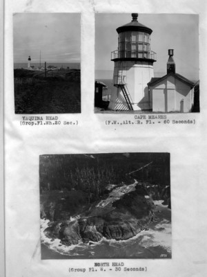
YAQUINA HEAD (Grop.Fl.Wh.20 Sec.)
(Image top right)
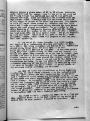
CAPE MEARES (F.W.,Alt. R. Fl. - 60 Seconds)
(Image bottom)
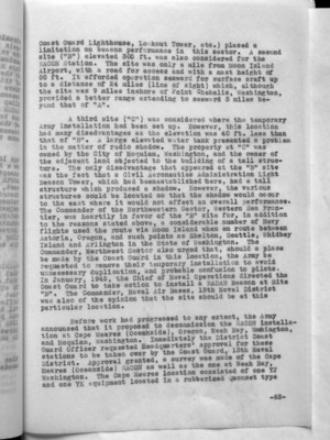
NORTH HEAD (Group Fl. W. - 30 Seconds)
82
signals beyond a close range of 20 to 30 miles. Mountains again restricted the beacon range to the north and east but the valley toward the northwest and out to sea provided maximum coverage. Much interference was received from the Cape Meares signal blending with the Tillamook indication on the scope at ranges of 45 miles and greater. The results of this Tillamook check seemed to indicate that the RACON there had little navigational value, whereas the Cape Meares beacon was used almost exclusively for navigation by the Blimp Squadron at Tillamook, Oregon, although the Tillamook RACON was good for homing to the air station when a landfall had been made with the Cape Meares RACON. The pilot suggested that one RACON, situated on the peak of the hill above Oceanside, Oregon, would serve the purpose of the two beacons then operating.
At the Naval Air Base, Seattle, the RACON Station was located in a rectangular clearing surrounded by trees on a hill. The trees encircled the beacon in all directions except west, being about 350 feet from it to the north and 125 feet distant to the east. On the west south-west, they were approximately 50 feet from the beacon. Although the grove only averaged 30 to 50 feet in height, they reduced the line of sight coverage of the beacon, and subsequently results of the test showed the contour curves to be determined largely by these trees and not by the hilly and mountainous terrain. It was the opinion of the pilot that increased coverage of the beacon could be obtained by cutting down or topping the trees within 150 yards radius of the antennae and/or elevating the antennae.
An Army YH RACON was established at Point Chehalis, Washington, on Coast Guard Property with the understanding that the installation was only temporary due to the fact that a completed RADAR beacon and Lighthouse with YJ, YK and YM equipment was under consideration by the Coast Guard for that vicinity. In September, 1944, the District Coast Guard Officer had requested the Chief of Naval Operation's approval to install this Point Chehalis RACON as the equipment and personnel for such a project were all available in the 13th Naval District. This approval was granted and the Bureau of Ships was directed to furnish technical assistance in connection with the Point Chehalis site survey.
The first site ("A") considered consisted of a flat portion elevated about 15 or 20 feet backed on the south by a wooded area on high ground. A number of dwellings ( the
-62-
83
Coast Guard Lighthouse, Lookout Tower, etc.) placed a limitation on beacon performance in this sector. A second site ("B") elevated 300 ft. was also considered for the RACON Station. The site was only a mile from Moon Island Airport, with a road for access and with a mast height of 50 ft. It afforded operation seaward for surface craft up to a distance of 24 miles (line of sight) which, although the site was 9 miles inshore of Point Chehalis, Washington, provided a better range extending to seaward 3 miles beyond that of "A".
A third site ("C") was considered where the temporary Army installation had been set up. However, this location had many disadvantages as the elevation was 40 ft. less than that of "B". A large elevated water tank presented a problem in the matter of radio shadow. The property at "C" was owned by the City of Hoquiam, Washington, and the owner of the adjacent land objected to the building of a tall structure. The only disadvantage that appeared at the "B" site was the fact that a Civil Aeronautics Administration Light Beacon Tower, which had been established there, had a tall structure which produced a shadow. However, the various structures could be located so that the shadow would occur to the east where it would not affect an overall performance. The Commander of the Northwestern Sector, Western Sea Frontier, was heartily in favor of the "B" site for, in addition to the reasons stated above, a considerable number of Navy flights used the route via Moon Island when en route between Astoria, Oregon, and such points as Shelton, Seattle, Whidbey Island and Arlington in the State of Washington. The Commander, Northwest Sector also urged that, should a place be made by the Coast Guard in this location, the Army be requested to remove their temporary installation to avoid unnecessary duplication, and probable confusion to pilots. In January, 1945, the Chief of Naval Operations directed the Coast Guard to take action to install a RADAR Beacon at Site "B". The Commander, Naval Air Bases, 13th Naval District was also of the opinion that the site should be at this particular location.
Before work had progressed to any extent, the Army announced that it proposed to decommission the RACON installation at Cape Meares (Oceanside), Oregon, Neah Bay, Washington, and Hoquiam, Washington. Immediately the District Coast Guard Officer requested Headquarters' approval for these stations to be taken over by the Coast Guard, 13th Naval District. Approval granted, a survey was made of the Cape Meares (Oceanside) RACON as well as the one at Neah Bay, Washington. The Cape Meares location consisted of one YJ and one YK equipment located in a rubberized Quonset type
-63-
84
hut situated on a hill at an elevation of approximately 335 ft. The only access to the station was by a foot path up a steep hill through a wooded area. All supplies and equipment were packed up and down this path. There was no emergency power line and no sanitary facilities or drinking water at the hut. It was definitely determined that that location was unsatisfactory from the standpoint of adequacy of equipment, lack of space for additional equipment or spares, lack of space for enlarging the present building and lack of accessibility. With this in mind, a survey was made of the Cape Meares Light Station, Tillamook, Oregon, with the idea of relocating the RACON equipment on Coast Guard property where adequate space was available at an elevation at approximately 325 ft. However, coverage to the eastward was restricted to high altitudes by a ridge, 150 ft. higher than the station. The coverage was comparable with that obtained at the present location. The Army had located in this particular site for security reasons and, as the war ended the necessity for such security, the more accessible position gained favor. In addition to other difficulties, when the Army RACON personnel were withdrawn, there were no facilities for messing, other than in the town of Oceanside, Oregon, (one mile distant) which Army Medical authorities had condemned as unsatisfactory from the standpoint of cleanliness. All things indicated that Cape Meares Light Station was the ideal place to move the equipment.
A similar inspection was made at the Neah Bay Army RACON Station which consisted of two YJ units and two CPN-3 Units located on top of a 1430 feet hill in a square wooden building. The station was accessible by a road constructed by the Army. The grade was steep, the road rough, but it was normally open the year around except for occasional falling of trees across the road. An attempt had at one time been made to top the nearby trees, but the Indians in the area objected. It was thought that satisfactory coverage could be given aircraft and perhaps surface craft without topping the trees, but as a flight had never been made it was not possible to make an accurate deduction. At that time, Army personnel were subsisted and quartered at a camp near the village of Neah Bay, Washington. It was necessary for personnel to be housed in the Neah Bay Indian Village, 6 miles from the RACON Station.
For reasons of inaccessibility and because good coverage was not provided for surface craft, a survey was conducted to determine whether or not adequate coverage for both air and surface craft could be given from a location on Tatoosh Island, Washington, in the vicinity of the former Navy RACON which had earlier been discontinued there. On 1 September, however, the station at Neah Bay, Washington, and at Cape Meares (Oceanside, Oregon) were transferred from
-64-
Box 252 List of supplies 1885, YB, YH Emery Pay 1887
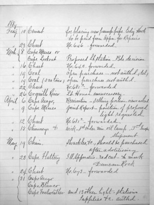
3
1887
Feby 10 Cement for placing new pump-pipe Ediz Hook to be paid from Appr. for Repairs Feby 23 Chart No. 646 - forwarded Mch. 8 Cape Meares or Cape Lookout Proposed Lt. station_Bds. decision Mch. 16 Chart No. 648 - forwarded Mch. 19 Coal open purchase - not authd., tel., Mch. 19 Coal (500 tons) open purchase not authd. Mch. 22 Chart No. 681a _ forwarded Mch. 26 Coquille River Lt. House unnecessary - April 6 Cape Arago, Reservation - selling portion - views asked April 9 Cape Meares Joint Report- position of proposed light requested April 12 Chart No. 681a _ forwarded April 15 Chimneys & wick - 1st Order Min. oil lamp, 3rd Insp, shipment May 29 Chain. shackles, &c, should be purchased after advertising May 23 Cape Flattery Ill. Apparatus - red cut - to mark Duncan Rock May 24 Chart No. 673 _ forwarded May 31 Cape Arago Cape Blanco Cape Foulweather and 13 other light-stations Supplies &c. authd.