About
Colonial North America at Harvard Library provides access to remarkable and wide-ranging materials digitized as part of an ongoing, multi-year project. When complete, the project will make available to the world approximately 650,000 digitized pages of all known archival and manuscript materials in the Harvard Library that relate to 17th- and 18th-century North America. Each item is connected to countless stories—of lives lived quietly and extravagantly, of encounters peaceful and volatile, and of places near and far – providing an opportunity to travel back in time, to rethink familiar stories, and to discover new ones.
Works
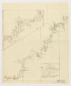
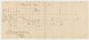
Curtis, Roger, Sir, 1746-1816. A chart of part of the country of Labrador / taken by order of comander Shieldham in a tour of the coast in the year 1773 by Lieutenant Roger Curtis. G3441.P5 1773 .C8, Harvard Map Collection.
Metadata:
Halifax in Nova Scotia. G3424.H2A3 1780 .M6, Harvard Map Collection.
Metadata:
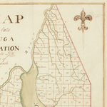
![Map of the inner parts of Virginia : from an actual survey made in the year 179[?]. G3893.M7 1795 .M3, Harvard Map Collection.](https://ids.lib.harvard.edu/ids/iiif/426558486/full/100,/0/default.jpg)
Map of the inner parts of Virginia : from an actual survey made in the year 179[?]. G3893.M7 1795 .M3, Harvard Map Collection.
Metadata:
Martin, Silvanus, cartographer. Rehoboth : December ye 21st AD 1774/ plan’d & measured by .. Silvanus Martin, land surveyor ; chain bearers were Joseph Pearce & Jnt. Wheeler. G3764.R35 1774 .M3, Harvard Map Collection.
Metadata:
Pope, John. A plan of land in contest between R. Billings & others, & N. Wheatley, taken by appointment of court held in Boston, A.D. 1771, from Kilby Street to the end of a wharf formerly Thos. Peck’s : with additions according to direction of court,
Metadata:
![Quebec : ville de l’Amerique septentrional dans la Nouvelle France avec titre d’eveshé situe [sic] sur le fleuve de St. Laurent a 310 degrez 17 min. de la longitudes et 46 degrez 55 min. de latitudes : elle fut assiegéé [sic] par les Anglois les Francois](https://ids.lib.harvard.edu/ids/iiif/426558452/full/100,/0/default.jpg)
Quebec : ville de l’Amerique septentrional dans la Nouvelle France avec titre d’eveshé situe [sic] sur le fleuve de St. Laurent a 310 degrez 17 min. de la longitudes et 46 degrez 55 min. de latitudes : elle fut assiegéé [sic] par les Anglois les Francois
Metadata:
Ratzer, Bernard. A copy of the general map the most part compiled from actual surveys by order of the Commissioners appointed to settle the partition line between the provinces of New York and New Jersey in 1769 / by Bernard Ratzer. G3811.F7 1769 .R3
Metadata:
Collaboration is restricted.
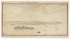
![Saccardy, Vincent, 1691. [Plan of Port Royal, Nova Scotia / based on the work of Vincent Saccardy]. G3424.A45 1690 .S3, Harvard Map Collection.](https://ids.lib.harvard.edu/ids/iiif/427293716/full/100,/0/default.jpg)
Saccardy, Vincent, 1691. [Plan of Port Royal, Nova Scotia / based on the work of Vincent Saccardy]. G3424.A45 1690 .S3, Harvard Map Collection.
Metadata:
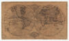
Shayler, William. The world / by Wm. Shayler. G3200 1768 .S5, Harvard Map Collection.
Metadata:
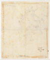
Survey of Cape Ann &c., 1799. G3762.A55 1799 .S8, Harvard Map Collection.
Metadata: