Business/Financial - St. George Land Ownership Diagram, circa 1873 [B-25]

ReadAboutContentsHelp

Pages

page_0001
Needs Review

page_0001

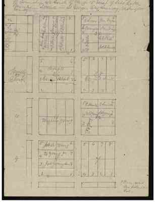
Of Township 42 South of Range 15 West of Salt Lake Meridian—Situate in St George City Survey Washington County

[sideways text] 28

2 ID YM'A 3 Ym 4 Y. 5
[blank] [blank] [blank] [blank]
[blank] [blank] [blank] [blank]
29
4 John Smith Patriarch 5 Geo. Q. Cannon
3 O Hyde 6 Lorenzo Snow
2 O Pratt 7 F. D Richards
1 [blank] 8 [blank]
[end of sideways text]

30

5 E Snow Jno. Taylor 6
4 A Carington W Woodruff 7
3 D H Wells C. C. Rich 8
2 [D H Wells] Jos F. Smith 1
27
Temple Block
26
5 6
4 Temple [Temple]7
3 Garden Block 8
2 1
25
5 6 7 8
4 George A. Smith 3 [George A. Smith] 2 [George A. Smith] 1 [George A. Smith]
10
[blank]
[blank]
[blank]
11
[blank] [blank] [blank] [blank]
Brigham Young [Brigham Young] [Brigham Young] [Brigham Young]
12
5 E Hunter E Smith 6
4 W.G. Young S. B. Young. 7
3 [J W Young] 8
2 J W Young 1
9
[blank]
[blank]
8
5 Jos A Young [Jos A Young] 6
4 B Young Jr [B Young Jr] 7
3 Jos. Young. Sen [Jos. Young. Sen ] 8
2 1
7
5 6 7 8
4 3 2 1
[blank] [blank]
[blank] [blank]
(Price was Ten dollars per Lot)
Last edit 4 months ago by Amber
page_0002
Needs Review

page_0002

St George Land Blocks near Temple Deeded to the Apostles

Last edit 4 months ago by Amber
Displaying all 2 pages