Pages
(seq. 1)
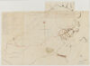
Plan of the TOWN of MARBLEHEAD on a scale of 40 rods to an inch
1 Old Meeting House; 2. Work House.; 3. Town House.; 4. New Meeting House.; 5. Episcopal Church.; 6. Academy; 7. Haymarket; 8. Ingall's Beach; 9. Newmarch's Head; 10. New Wharf; 11. Bartol's Head; 12. [?] Wharf; 13. Skinner's Head; 14. Huit's Hill fortified in 1775.; 15. Orne's Island; 16. Gerry's Island; 17. Pitman's Marsh; 18. Tinker's Island Pond; 19. Andrew's Head & Coombs Fish House.; 20. Beacon Hill; 21. Severett's Hill; A. Middle [Avect.?]; B. Water S.; C. Back S.; D. Mill S.; E. Barnard S.; F. - -; G. Washington S.; H. Darling S.; I: Prospect S.; J. Tattle S.; K. Green S.; L. Fish S.; M. ; N.; O.; T. [?]; Q.; R. Pond S.; S. Ferry S.; T.; U. Academy S.; V. Essex S.; From 11 to 19 is 127 rods 3/10.; Old Ferry to Salem; Haskell's Cove; Naugus Head; Chever's Cove; Cloutman's Point; Fluant's Point; Dolliber's Point; Scott's Beach;Peach's Point; Dolliber's Cove; Peach's Cove; Burying ground Hill; Fort; Homan's Cove; Codner's Cove; Waldron's Cove; Red Stone Cove; Black Jack Point; Pitch of the Neck; Tom Moore's Rocks; Sea; Neck; Harbour NE 1/2 E; Devereaux's Beach; Sea; Road to the Farms and Beaches; Boundary line on Salem, Lynn side; Road to Lynn; Silver Hole; Fetting Rock; Salem; Dungeon Pasture Road; Forest River; Bridge; Gardiner's Mills; Lower Road; Road to Salem; Guide Post; Bridge on Bubior Plain; Newtown Bridge; Hill Square; Red's Pond; Powder Hous; Road to the ferry; path; Marblehead side of Salem Harbor