About
Colonial North America at Harvard Library provides access to remarkable and wide-ranging materials digitized as part of an ongoing, multi-year project. When complete, the project will make available to the world approximately 650,000 digitized pages of all known archival and manuscript materials in the Harvard Library that relate to 17th- and 18th-century North America. Each item is connected to countless stories—of lives lived quietly and extravagantly, of encounters peaceful and volatile, and of places near and far – providing an opportunity to travel back in time, to rethink familiar stories, and to discover new ones.
Works
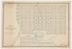
A chronological table in which the towns and districts now composing the state of Massachusetts are arranged in the order of years in which they were incorporated and divided into counties. G3761.A1 1790 .C4, Harvard Map Collection.
Metadata:
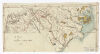
A map of North Carolina. G3900 1794 .M3, Harvard Map Collection.
Metadata:
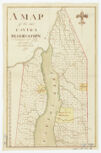
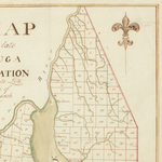
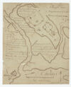
A map of the late Cayuga reservation : surveyed into lots generally of 250 acres each. G3802.C37 1795 .M3, Harvard Map Collection.
Metadata:
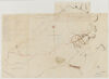
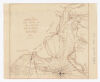
A map of the propos’d roads and canals in Pensylvania 1770. G3821.P2 1770 .A4, Harvard Map Collection.
Metadata:
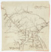
A plan of the borough of Clinton situated on the east side of the river Unadella in the county of Montgomery in the state of New York. G3804.C571 1787 .P4, Harvard Map Collection.
Metadata:
Belknap, Jeremy, 1744-1798. Three maps of the boundaries between the United States and the Indians : as established by the Treaty of 1795 / Dr. Belknap. G1106.S4 B4 1795, Harvard Map Collection.
Metadata:
Bentley, William, 1759-1819. Plan of the town of Marblehead. G3764.M3 1800 .B4, Harvard Map Collection.
Metadata:
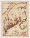
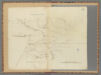
Carleton, Osgood, 1742-1816. The district of Main : from the latest surveys / by Osgood Carleton, delin. G3730 1793 .C3, Harvard Map Collection.
Metadata:
Caulkins, John. A plan of the Indian antiquities discovered on the Western waters. G4084.M28E15 1785 .C3, Harvard Map Collection.
Metadata:
Cowley, R. Charles Town, South Carolina : with a chart of the bars & harbour / by R. Cowley. G3914.C3P55 1781 .C6, Harvard Map Collection.
Metadata: