Pages
(seq. 1)
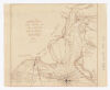
Charles Town South Carolina with a Chart of the Bars & Harbour By R. Cowley. ; x x; (1781.); W M. M.
Ship Channel Light {House} W by N.; the Swash W by S.; 4; 3; 4; 4; 5; 5; 3; 3; 3; 3; 4; 5; 3; 5; 7; 4; 6; 3; 4; 5; 5; 5; 4; 8; 5; 5; 5; 9; 4; 4; 5; 3; 3; 2; 3; 3; 5; 9; 9; 10; 10; 10; 7; 5; 7; 7; 8; 5; 7; 5; 8; 10; 10; 9; 6; 5; 6; 13; 13; 6.5; 5; 5; 3.5; 3; 3; ~0.5; ~0.5; 5; 3; 3; 5; 6; 8; 5; 5; 6; 7; 6; 5; 4; 4; 6; 5; 4; 3; 4; 4; 4; 4; 4; 6; 5; 6; 3; 4; 5; 3; 4; 5; 6.5; 6; 6; 5; 4; 5.; 6; 5; 5; 6; 4; 6; 5; 6; 5; 5; 6; The Church NW over the Light house Creek; Quarter House; CHARLESTOWN; Gibbes Fort; Dorrels Fort; Exchange Battery; Gaddsden Fort.; Ashley River; Town Creek; Cooper River; Wappoo Creek; Stones Battery; James Island Creek.; Shutes Folly; Hoggs Island Creek; Hobcaw Point; Hog Island; Farquharsons Distillery; Haddrells Point Ferry; Mount Pleasant; Barracks; A Redoubt to defend the Bridge; Gaddsdens Bridge; Fort on Bridge; Redoubt; Fort Moultrie; Sullivans Island; Clintons advanced Post; Long Island; advanced Guard; 5 feet; 8 feet Channel; Middle 8 feet Channel; Stone Breaker; Normans Land; 12 feet; feet 10; Lawford Channel; Beach; Light house; Morris Island; Acteon; Sphinx; [?]nt; Fort Johnston; James Island