Pages
(seq. 1)
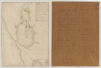
A - Riviere den haut; b - terrain du port Royal; c - petite riviere; d - premier basin bon mouillage; E - Lisle aux chevres; f - mechante passe, aux fous; g - bonne passe; h - grand basin bon mouilage; JJ - platins qui sont couverts; LLLL - Roches qui couvrents en marée; m - Riviere a lorignal; n - R, et ile imbert pour les barques; o - La] passe; p - Baye francoise; q - Baye Ste marie; R - terre qui abouti a lile longue; A; b; c; d; E; f; g; h; IJ; L; L; L; L; m; n; o; p; q; R
1 2 3 Lieües a 2400. toises La Lieües
Saccardy fils drawn 1690; One of originals drawn by Son of Vincent Saccardy, Engineer general for the King in Acadie.; Saccardy returned to France from Acadie in 1690 Died died at Amboise, France, in 1691. See Acadiensia Nova WIM. Section on "Saccardy"; There are three or four duplicates of this map in the hydrographic department in Paris, which I saw in October 1933 during my visit to this department.; Wm Inglis Morse; April 1 1935; 17 Fresh Pond Pky; Cambridge, Mass