Pages
18v
Disotto anilo miglia setteciento epiu chelameta sabbione eterra paese adusto perlochaldo vento enonve acqua chesargha divena poy eunmontte dumila treciento chevolgharmente sichiama charena ede daltizza molto smisurato enelle storie atalante chiamato
Dalmonte almare ellaria temperata cheiventi adusti nonpossono passare encierti parti emino chunagiornata edove tre oquatro presso almare equesta parte eassai popolata ebuoni terreni pomati eddafructare ensulla cima perla grande altura elpiu deltempo eneve egranfreddura
Dila dalmonte sonchaldi roventi popoli radi esterile terreno torrida zona perlisecchi venti divelenose ferruchole pieno edella terra homai stiam chontenti eachontare lamarina verremo chollaiuto didio checcieldimostra elquale estato effia laghuida nostra
19r
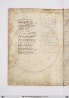
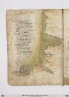
Incomiciando dalmeridionale lito delmare inssulla stretta boccha che miglia sedici elargho ilchanale eadongni parte monte erocche sta laccitta disetta laqual sale sei giorni agrecho disopra amoroccha ealtretanto adirinpetto adessa permezzo di lagran cipta difessa
Disotto asetta forse mille miglia giu per quellito sapocha notizia dandarvi luomo dirado siconsiglia ne perdiletto ne peravarizia egia ne furono chepermaraviglia vollono passare piu voltre echontrestizia diloro eddiloro giente fertalgita chemai poy non siseppe dilor vita
In quelle mille miglia dimarina verso libecco truovi prima arzilla poy laracha leassai vicina salle poy seghue che unabuona villa unfiume cheallato lechonfina chedalmonte atalante sidistilla permezzo fessa passa ecientocinquanta miglia ainsinola easetta altretanta
[Initial: Two-line decorated capital letter "I" in blue with red pen flourishing (including harping and frogspawn) introduces the text, with a manicule in the margin.]
[Image: Right and lower margin, a map of the Straits of Gibraltar and the coasts of southern Spain (label: Spagnia) and northwest Africa oriented with east at the top. The map extends the entire length of the page on the right hand side. (label: Spagnia) appears at the top left, and the northwest coast of Africa runs lengthwise down the page. The Mediterranean Sea (label: Mare Meridiano) at the top flows into (label: Mare di Spagnia) at the bottom. The African coast is labeled top to bottom: (label: Septa), (label: Rabat), (label: Fessa), (label: Arzilla), (label: Meroe), (label: Laraccia), (label: Çamor), (label: Fassi), (label: Garolla). (label: Rabat) is illustrated by a tower, while (label: Fessa) and (label: Meroe) are represented as walled towns. A white flag flies above Meroe. The Canary Islands at the bottom of the page are labeled: (label: Lancilotto), (label: Fr***taria), (label: Canaria), and (label: Delinferno)—the last referring to Tenerife. Scribal notes directed the artist to paint them in particular colours. (Note: a) for white or alba appears on (label: Delinferno) and (label: Lancilotto); (note: Ro) for red or rosso appears on (label: Canaria).]
19v
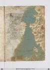
Niffe zamor saffi ghazola emessa una dopo laltra cinquanta inottanta miglia si truova poy dila daessa epiu oltre nonpare chenascha pianta nechessitruovi senon rena spessa cierchando lariviera tutta quanta veggiono daterra piu isole imare canaria ealtre dipoccolo affare
Seghuendo illito verso loriente treciento miglia sta hone insalmare disopra asetta andando colponente echi atremisen volessi andare fraterra atre giornate oquasimente one chonchartagine sta delpare afar pileggio chonvento africhone dugiento otanta miglia adacquilone
Poy trallevante egrecho sta horano piu alto cientomiglia insuquellito lacipta ditenes per quella mano piu su cientocinquanta tiensuo sito epoccho piu diciento dilontano quella dalgieri laquale diriza ildito adacquamorta verso tramontana questo paese apocha terra piana
[Image: Left and lower margins, a map of the coast of Spain and north Africa from Gibraltar to Cartagena and Algiers. The large body of water (label: Mare mediterano) is painted in grey-green with a wave pattern in a light brown. In the (label: Mare di Spagnia) there is an unlabeled island, representing Majorca, which has been painted with a few strokes of red. A scribal (note: Ro[sso]) calling for red is visible at the top of the island.
Many cities and regions are labelled. On the left/European side, top to bottom: (label: Cartagena), (label: Almeria), (label: Saruignia), (label: Granata), (label: Lisbona), (label: Spagnia), (label: Indi), (label: Sibilia). On the right/African side: (label: Algieri), (label: Brescia), (label: Mestegani), (label: Arçeu), (label: Orano), (label: Seren), (label: One), (label: Melina). All are in red ink except for "Indi" (?) in black.]
20r
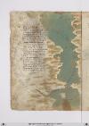
Indi adbuggiea sonmiglia ciento venti pur trallevanta egrecho eposccia ebona piu su dugiento pur perdetti venti eluna elaltra cipta siragiona dayvi aciento miglia poi seghuenti truovi biserti esecondo chesuona performa quivi presso fu chartagine lagrande esene vede alchuna ymagine
Tunisi fapiu la suo residenza sesantta miglia edun gran gholfo aporto laqual citta sighuarda chon fiorenza aduno occhaso quasi edunorto capo direngno ede digram potenza eben dotata terra enon atorto chelle nelmezzo dillabarberia presso aitalia piu chaltra visia
Sta con Jerusalem econsibilia inclinati dacuro edazaffiro esta vicina perdugiento miglia alleduo maggiorisole digiro lequali sono lasardingna ellascicilia quasi intriangholo quando ben vimiro africha stapo[i] vermeridiano passato capo bono adestra manno
[Image: Right margin, a map of the Mediterranean Sea including (on left) the southern tip of Sardinia (label: SARDIGNIA), then from top to bottom (east to west) at right, the western tip of Sicily (label: Sicilia), and the North African coast: (label: Sussa), (label: Cartagi), (label: bona), (label: Tuniçi), (label: biserti), (label: Bona) again, (label: Storia), (label: bugea) with a small image of a walled city, (label: titelis) (modern Dellys, Algeria), and (label: Algieri). The Mediterranean is colored in a grey-green wash.]
20v
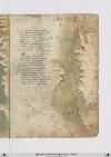
Daafricha achapulia eadfaciesse sonmolte secche dallito remote echivole navichare indi achapesse fraesse ellito perchanale sipuote eseghuon poy fino atrasamabesse maqui bisongna chedifuori sirote datunisi insiqui per maestrale treciento miglia sono perdiritto strale
Poy tripoli citta dibarberia cientoventicinque miglia inverlevante emisurata superquella via dugiento miglia eduo volte altretante sonfino adrausen pertraversia [corr. pertraverso?] dove fa unchapo ilgram monte tatalante lascciando ungholfo dove e daman diretta zunaro epoi berniccho etolometta
Echi girasse ilgholfo perchostea sarebonpiu dellemiglia dugiento dalchapo dirausen abonondrea sonciento miglia opiu perdetto vento lungho piusu dugiento parchestia eindi adalisandria aquatrociento chequasi imezzo desse sta larassa edequesto paese terra bassa
[Image: Right and lower margins, a map showing the continuation of the North African coastline, top to bottom / east to west: (label: lucho), (label: Bonandrea), (label: Tolometta), (label: Bernicho), (label: Misim?), to (label: Tripoli) with a small image of a walled city, (label: Rasamatis), (label: Capisse) at the end of an inlet or bay, and (label: Capo bona), with a detailed illustration of a large walled city that looks much like Renaissance Florence.]