Pages That Mention Cape Perpetua
1871-1872 keeper selection and LH building Vol. 336
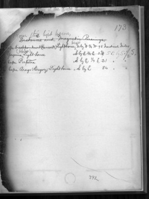
23
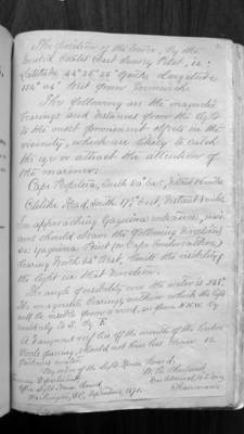
From the light house
Cape Disappointment (Hancock) Lighthouse Bears N by W 3/4 W 95 Nautical Miles
Yaquina Harbor Light-house Bears SE by S 1/2S
Cape Perpetua Bears S by E 3/4 E 21 Nautical Miles
Cape Arago (Gregory) Lighthose Bears S by E 84 Nautical Miles
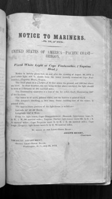
p-2 Notice To Mariners
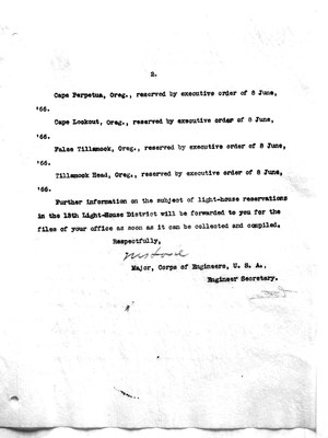
2
The position of the tower, by the United States Coast Survey Pilot, is: Latitude 44 degrees 36 minutes 35 seconds north, Longitude 124 degrees 04 minutes west from Greenwich.
The following are the magnetic bearings and distances from the light to the most prominent objects in the vicinity, which are likely to catch the eyes or attract the attention of the mariner:
Cape Perpetua, South 20 degrees east, distant 26 miles. Celilike Head, South 17 1/2 degrees east, distant 8 miles.
In approaching Yaquina entrance, mariners should observe the following directions, viz: Yaquina Point (or Cape Foulweather) bearing north 34 degrees west, limits the visibility of the light in that direction.
The angle of visibility over the water is 238 degrees. The magnetic bearings, within which the light will be visible from a vessel, are from N.N.W. by southerly to S. by E.
A dangerous reef lies off the mouth of the harbor. Vessels passing should not have less than 12 fathoms water.
By order of the Light-House Board:
Treasury Department Office Light House Board Washington, D.C. September 1871
W.B. Shubrick, Rear Admiral, U.S. Navy Chairman
3
Notice to Mariners No. 34, of 1873
United States of America - Pacific Coast - Oregon
Fixed White Light at Cape Foulweather, (Yaquina Head)
Notice is hereby given that, on and after the evening of August 20, 1873, a fixed white light will be shown from the tower recently erected on Cape Foulweather, (Yaquina Head,) Oregon.
The focal plane is at a height of 81 feet above the ground and 150 feet above sea level. In clear weather, the eye being 15 feet above sea level, the light should be seen at a distance of 18 1/2 nautical miles.
The illuminating apparatus is a lens of the 1st order, fixed, illuminating 240 degrees of the horizon.
The tower is of brick, painted white, and the lantern is painted black.
The keeper's dwelling, a two story frame building east of the tower, is painted white.
The approximate position of the light-house is as follows:
Latitude 44 degrees 43' 30" North Longitude 124 degrees 5' West
From the light-house, Cape Disappointment (Hancock) light-house bears N. by W. 3/4 W. 94 nautical miles; Yaquina (Harbor) light-house bears S.E. by S. 1/4 S. 3 1/4 nautical miles; Cape Perpetua bears S. by E. 3/4 E. 24 nautical miles; Cape Arago (Gregory) light-house bears S. by E. 84 nautical miles.
By order of the Light-House Board:
Joseph Henry, Chairman
Treasury Department Office Light-House board, Washington, D.C., July 25, 1873
Box 247 1899 to 1900 JA land 4000 app 1866 reserved
8
Cape Perpetua, Oreg., reserved by executive order of 8 June, '66. Cape Lookout, Oreg., reserved by executive order of 8 June, '66. False Tillamook, Oreg., reserved by executive order of 8 June, '66. Tillamook Head, Oreg., reserved by executive order of 8 June, '66.
Further information on the subject of light-house reservations in the 13th Light-House District will be forwarded to you for the files of your office as soon as it can be collected and compiled.
Respectfully, ??? Major, Corps of Engineers, U.S.A. Engineer Secretary.