Pages That Mention Thistle Path
1873 Copying Book: Superintendent's Letters, 2005.062.005
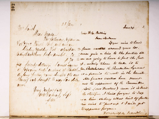
CB03_0202
202
Dear Madam
The following repairs on Lot #2372 Thistle Path will cost viz;
| Grading & sodding Lot about | $40.00/100 |
|---|---|
| Putting Buckthorn Hedge around Lot | 30.00/100 |
| [total | $70.00/100 |
Yours respectfully Jas W Lovering, Sup't per A.C.
.
Dear Madam
If you wish to have fence erected around your lot, please give a line to the parties who you are going to have to put the fence up, asking them to take it to Mr. Batchelder 16 Pemberton Square & get a permit to work in the Cemetery. All fences erected here must have the approval of the Committee on Lots, (our Trustees) and it is desirable therefore, I think for you to drop us a line stating what kind of fence you wish to put up & I will get the approval for you.
Yrs Respectfully James W Lovering
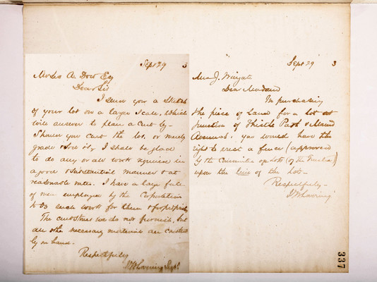
CB03_0337
Dear Sir
I send you a sketch of your lot on a larger scale, which will answer to plan a curb by - Should you curb the lot, or merely grade & sod it, I shall be glad to do any or all work required in a good & substantial manner & at reasonable rates. I have a large force of men employed by the Corporation to do such work for them & for proprietors.
The curbstones we do not furnish, but all other necessary materials are constantly one hand.
Respectfuly J.W. Lovering Supt
Dear Madam
In purchasing the piece of land for a lot at junction of Thistle Path & Mound Avenues, you would have the right to erect a fence (approved by the Committee on Lots (of the Trustees)) upon the line of the lot -
Respectfuly J.W. Lovering
337
1860 Copying Book: Secretary's Letters and Treasurer's Letters, 2005.062.003
Copying Book: Secretary's Letters, 1860 (page 206)
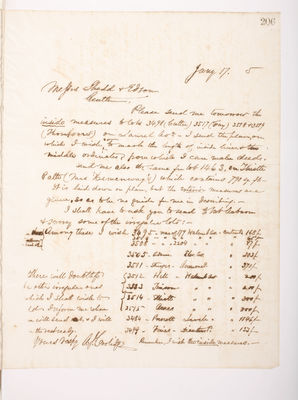
206
Gentlemen,
Please send me tomorrow the inside measures to lots 3498 (Cutter) 3517 (Fray) 3518 & 3519 (Thompsons) on Laurel Ave. I send the plans, on which I wish ^you to mark the length of inside lines, & the middle ordinates, from which I can make deeds.
Send me also the same for lot 1463, on Thistle Path (Mrs Hemenway's) which contains 790 sq. ft.-
It is laid down on plan, but the exterior measures are given, so as to be no guide for me in describing.-
I shall have to ask you to send to Mt Auburn & survey some of the irregular lots:- [?]} [?]} each other}
Among these I wish
| 3495 | rear of 179 Walnut Av. | contents | 168f. |
|---|---|---|---|
| 3516 | rear of 179 Walnut Av. | contents | 65f |
| 3508 | rear of 2204 Walnut Av. | contents | 87f. |
| 3505 | Adams - Elm Av. | contents | 203f |
| 3511 | Sturges - Anemone P. | contents | 370f |
| 3512 | Hill - Walnut Av | contents | 200f |
| 3513 | Timson - Walnut Av | contents | 200f |
| 3514 | Elliott -Walnut Av | contents | 300f |
| 3515 | Ames - Walnut Av | contents | 300f |
| 3484 | Prescott Larch Av | contents | 1846f |
| 3499 | Fines - Dianthus P. | contents | 133f |
There will doubtless be other irregular ones which I shall wish to [?]. Inform me where you will send out & I will [?] the rest ready.
Yours respy
1865 Trustees Meeting Minutes, Volume 4, 1831.005.004
Trustees Records, Vol. 4, 1865 (page 063)
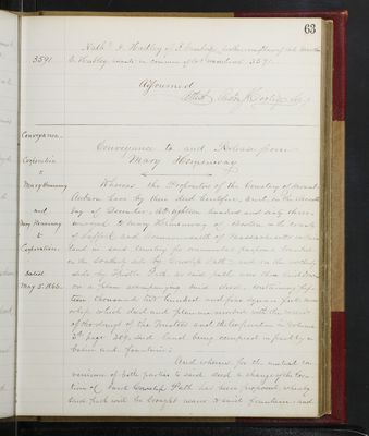
63
Nathl I. Hadley of Cambridge, brother & one of heirs of late Martha E. Hadley, tenants in common of lot numbered 3591.
Adjourned Attest Austin J. Coolidge Sec.y
---------------
Conveyance _ Corporation to Mary Hemenway and Mary Hemenway to Corporation _ Dated _
Conveyance to and Release from
[ left arrow ] ––––––––––– [ right arrow ]
Whereas the Proprietors of the Cemetery of Mount Auburn have by their deed heretofore, to wit, on , conveyed to Mary Hemenway of Boston, in the county of Suffolk and Commonwealth of Massachusetts certain land in said Cemetery for onramental purposes, bounded on the southerly side by Cowslip Path, and on the northerly side by Thistle Path, as said paths were then laid down, on a plan accompanying said deed, containing fifteen thousand two hundred and five square feet, more or less, which deed and plan are recorded with the records of the doings of the Trustees and the Corporation in volume 3d page 309, said land being occupied in part by a basin and fountain;
And whereas, for the mutual convenience of both parties to said deed a change of the Creation of said Cowslip Path has been proposed, whereby said path will be brought nearer to said fountain, and
Trustees Records, Vol. 4, 1865 (page 208)
208
_
Trustees' Annual Report _ Trustees' Report.
Among the occurrences worthy of note in the last years' history of Mount Auburn, is the purchase of two lots or pieces of land situated on the oustide of the Cemetery, and separated from it by an intervening road. One of these, sometimes called the "Stone Meadow" is situated on the easterly side of Coolidge Avenue, and has been brought of the heirs of Cornelius Stone, at the price of $1000 ~ per acre, the lot containing over five and a half acres, and costing the Corporation $5,543.75. This lot, consisting in part of low or wet land, is to be used as a place of temporary deposit for stone, rubbish and building materials, thereby releasing a more valuable portion of land now used for the same purposes within the Cemetery. It is possible that, at some future time, the engine house with its appurtenances may be removed in the same direction, with the same economical purpose. The other purchase is that of a part of an acre of land, with a dwelling house thereon, situated nearly opposite the front gate of the Cemetery, and bought of A. McDonald, for $4,000 ~. For various reasons, it was thought desirable that the Corporation should control this estate.
The work of reclaiming low lands in eligible situations has gone steadily forward. The entire hill on which the Superintendent's house stood, thirteen years ago, has been levelled, and the earth used to fill up the meadow about Halcyon Lake, and also to restore the necessary grade where made lands have settled, as in some parts of the Lawn, and of the meadow adjoining Thistle Path.
 Follow Us on Instagram