Pages
p. 81
at from 10 to 15 miles distance. I was walking on the poop with the Captain about 10 oclock when some lights we had seen on shore, & which we thought were fires, assumed the appearence of a light house. the Capt. at the moment thought we had found Table Bay, & immediately brought the ship to. it however turned out to be that we were just off Hants Bay, & that the lights we had seen were only fires kindled by the Kaffirs. They burned until 4 oclock in the morning.
April 2nd 1858 We made sail again at (11 struck through) 6 oclock this morning with a light breeze, & Kept on along the coast as we went on. We came in sight of the Devils Peak, Lions Rump & Head & at 12 oclock we Saw the Ships lying in the Bay.

p. 82
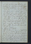
By Moonlit [Pencil Drawing of hills and sea seen from ship] Lions Rump Cape of Good Hope posterior extremity seen from the Belgravia on 1st April 1858 when the ship was hove too.
p. 83
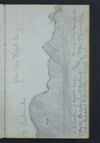
[Pencil drawing of hills seen from on board the Belgravia]
from near Hants Bay
2 Continuation Cape
Structure of lights seen Hants Bay the right extremity the from the Belgravia 15 miles at Cape of Good Hope sea supposed to be at the entrance of
p. 84
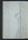
[Pencil sketch of hills seen from on board Belgravia ]
Cape of Good Hope & Cape Point. Seen from belgravia 2nd. April 1858.

p. 85
[Pencil sketch of hills from on board Belgravia ]
Table Mountain from the West. Constantia to the right. seen from "Belgravia" April 2/58 on the other side & Lions head