Pages That Mention Foulweather
Vol 313 LH at CF letter 1873
2
13th Customs Revenue L. Dist. Port Townsend Wash. Ter. Rufus ??? Eng. January 31. 1873. Special Treasury Agent. Port Townsend, Wash. T. Sir x x x x x From my experience of Puget Sound navigation and the statements of ??? and masters of vessels I feel convinced that the shipping interests on said waters, would be greatly benefited by the establishment of Light Houses on Foulweather Point and Possession Point. It first would indicate that entrance to Hood Canal, an arm of Puget Sound, some sixty five miles in length, on which are situated important milling settlements, shipping lumber to all parts of the world.
The one at Possession Point, a point southeast of Seatchets Head (both of the latter point on (Whidbey Island) would indicate the entrance to Saratoga Passage, leading from the waters of Puget Sound proper, through Deception Pass, back into the Straights of Fuca proper, and both would enable the shipping from and for up-sound ports to keep the ??? channel without
YH LH location and building Vol. 311
8
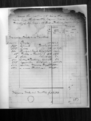
(Form No. 75.) Estimate for section of 1st Class Seacoast Lights near Cape Foulweather, Oregon. Made by Major Robert L.H. Engr. 13th Dist - Portland Oregon. July 18
Masons work and materials
314,000 Brick 12.00 3768 895 Cement Barrels 5.00 4475 155 Lime Barrels 2.50 387.50 320 Sand and Gravel Cubic yards 2.00 640 15 Rubble - Random Cubic yards 11.333 170 5 Sills Granite 12.00 60 100 Lathing & Plastering Yards 6.50 50 275 Excavation Cubic yards 6.50 137.50 1000 Labor Masons Days 5.50 5500 1500 Labor Tenders Days 3.00 4500
| Estimate | Actual Cost. | |||
|---|---|---|---|---|
| Price | Amount | |||
| Mason Work and Materials | $19688 |
34
Copy of Letter addressed to Charles Bain Astoria. Oregon W Braden Portland. " (Oregon) Abbott & Co " (Portland Oregon) Duplicate of page 462 Office. L.H. Engineer 13th Dist Portland, Oregon July, 22. 1871.
Sir. I have received a bid for building a keeper dwelling at Cape Foulweather. the duplicate of the one you bid upon for Cape Disappointment. I had expected to do the work by days labor, but it is possible that it may be let out by contract, if by such a course the work can be done much more economically. The building would have to be inclosed (sic) by the 1st of November 1871. and completed before June 30. 1872. The site of the Lighthouse is about 4 1/2 miles from Newport on Yaquina Bay. A half mile of road on the Cape which will be built by the government will give a wagon road between the Cape and Newport. 280
43
for the 1st quarter: at the same time I secured a storeroom that would be of service in building the Light House at Cape Foulweather.
I considered I had a right to hire a storeroom as well as build one and only made a written agreement to prevent the owner raising the price when he finds it was worth so much to me.
I have been in the habit of making written agreements for my own protection and to prevent any misunderstandings in all purchases in open market when the transaction requires time for its completion.
These do not seem to me to be contracts in the sense generally used in the laws and I have not located them as such.
I forward this lease, with the request for
286
65
(3)
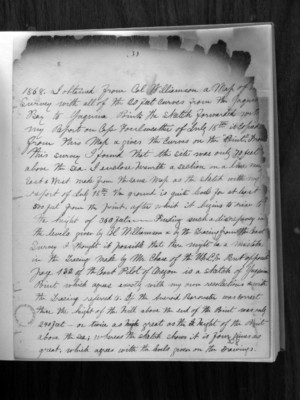
1868. I obtained from Col. Williamson a map of the survey with all of the 20 feet curves from the Yaquina Bay to Yaquina Point. The sketch forwarded with my report on Cape Foulweather of July 18th is copied from this map and gives the curves on the "Point". From this survey I found that the site was only 70 feet above the sea. I enclose herewith a section on a line near East and West made from the same map as the sketch with my report of July 18th. The ground is quite level for at least 500 feet from the point, after which it begins to rise to the height of 360 feet. Finding such a discrepancy in the levels given by Col. Williamson and by the tracing from the Coast Survey I thought it possible that there might be a mistake in the tracing made by Mr. Chase of the U.S.C.S. but opposite page 132 of the Coast Pilot of Oregon is a sketch of Yaquina Point which agrees exactly with my own recollections which the tracing referred to. If the aneroid barometer was correct the height of the hill above the end of the Point was only 240 feet - or twice as great as the height of the Point above the sea; whereas the sketch shows it is four times as great, which agrees with the levels given on the drawings.
308